


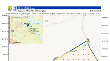
The 2026 hunting map for the Mothershead Unit of the Rappahannock River Valley National Wildlife Refuge.
- Key Features: The map outlines the refuge boundary, a designated "No Hunting Zone," extensive hunting areas marked with hunter symbols, dirt hunting access routes (including Liberty Farm Rd and SC696), parking lots, gates, and secondary state routes.
- Geography & Inset: An inset map in the upper-left corner shows the regional context near Fredericksburg, Richmond, and the refuge.
- Notes: A note specifies that large game may only be harvested with archery tackle, except for spring gobblers.
- Metadata: Produced on August 1, 2026, using an ESRI Environment basemap with a WGS 84 Web Mercator projection.
Publication date
Type of document
Map
Media Usage Rights/License
Public Domain